Summary
- 35,000+ hectare, high-potential brownfield copper-moly-silver-gold project associated with the Midcontinent Rift (“MCR”) in Ontario, Canada, which until 2021 had never been fully consolidated
- Recent porphyry and breccia drill holes as well as past copper production from two mines suggest the potential for larger intrusion related copper mineralization
- The project benefits from its strategic proximity to substantial infrastructure
Location and Ownership
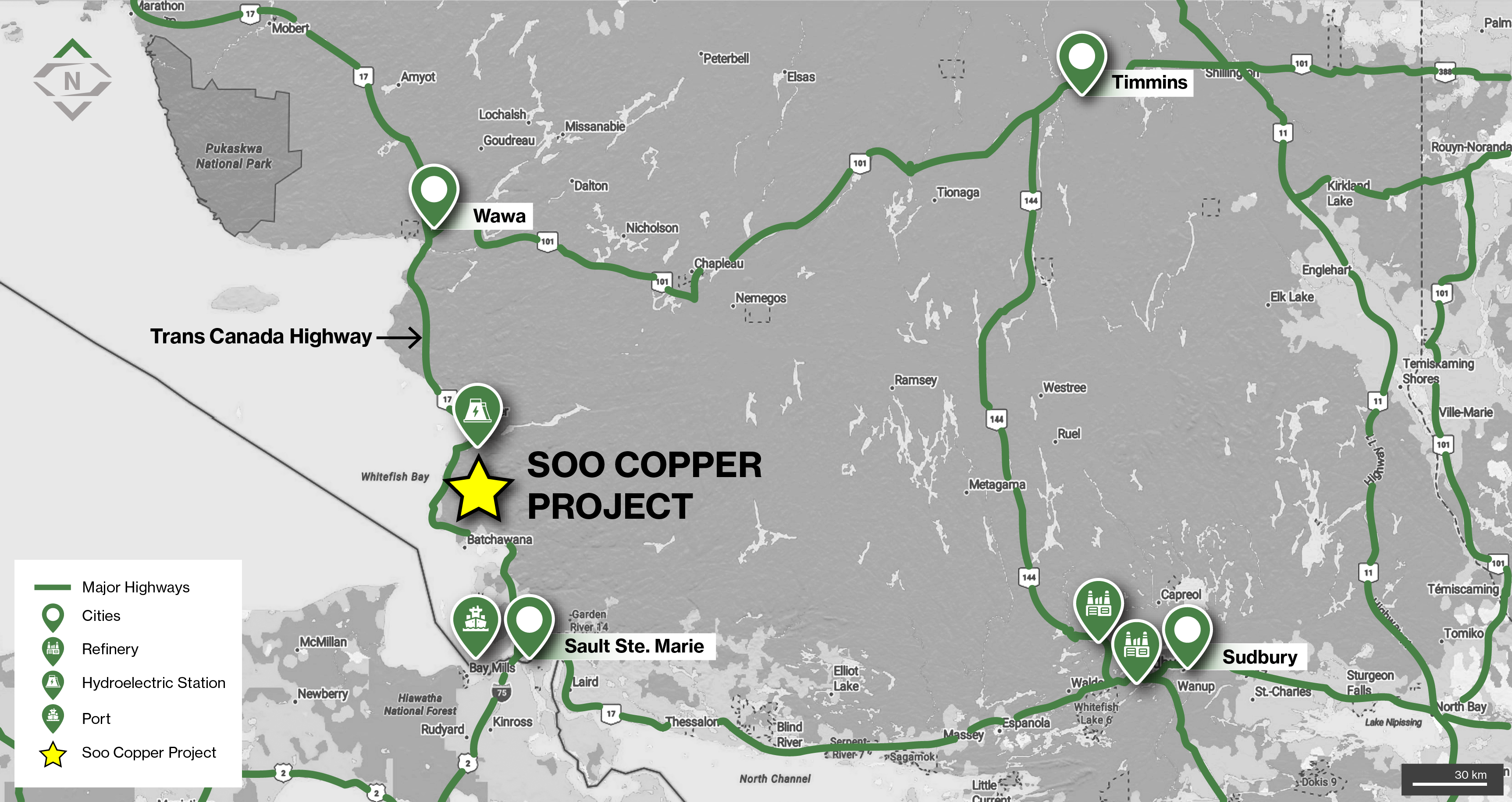
Location of the Soo Copper Project in Ontario, Canada located in proximity to significant infrastructure
- 100% owned and located in an area with a rich mining history, 30km from Batchewana Bay and situated between Wawa, Sault Ste. Marie, Sudbury and Timmins in Ontario, Canada
- The project is intersected by numerous highways and roads including the Trans-Canada Highway (Highway 17), which crosses the westernmost portion and provides major road connection to the city of Sault Ste. Marie
- The project is located 90km from the Port of Sault St Marie, and 40km from the Montreal River, which includes four hydroelectric dams and generating stations
- The project is also ideally located in proximity to two copper smelters outside of Sudbury
Geology
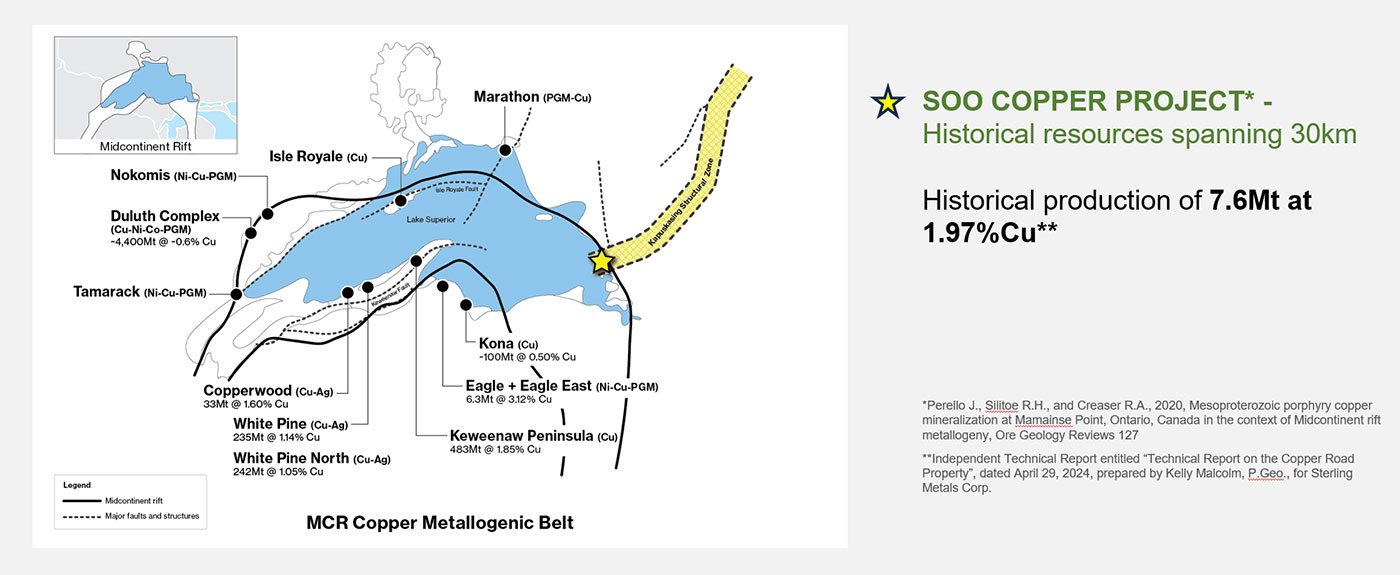
- Situated within the Mamainse Point Formation of the Keweenawan Group within the Proterozoic Southern Province, on the eastern edge of the MCR
- The MCR is home to numerous past-producing and present deposits around Lake Superior, including the prolific native copper deposits of the Keweenawan Peninsula in the U.S., mined for more than 150 years
- Porphyry mineralization at Soo Copper has been sourced to the same age range as the primary mineralizing event within the MCR1
- The Mamainse Point area has a long history of prospecting, exploration, and mining activity dating to the mid-1800’s with the production of copper, silver, and gold from the Copper Corp Mine from 1965 to 1972 and the Tribag Mine from 1965 to 1973, now known as the Soo Copper Project
- The Copper Corp mine reportedly produced 1.1Mt at 1.2% Cu while the Tribag Mine produced 6.5Mt tons at 2.75% Cu1
- Following closure of the mines, significant sections of the district were closed to staking by the Ontario Government
- As a result of this, and fragmented land ownership, the area has seen only sporadic mineral exploration since the 1970
1 Independent Technical Report entitled “Technical Report on the Copper Road Property”, dated April 29, 2024, prepared by Kelly Malcolm, P.Geo., for Sterling Metals Corp.
Exploration
The Soo Copper Project is a large-scale copper asset located ~80 km north of Sault Ste. Marie, Ontario, covering ~35,000 hectares across a 30 km-wide corridor with excellent infrastructure and access.
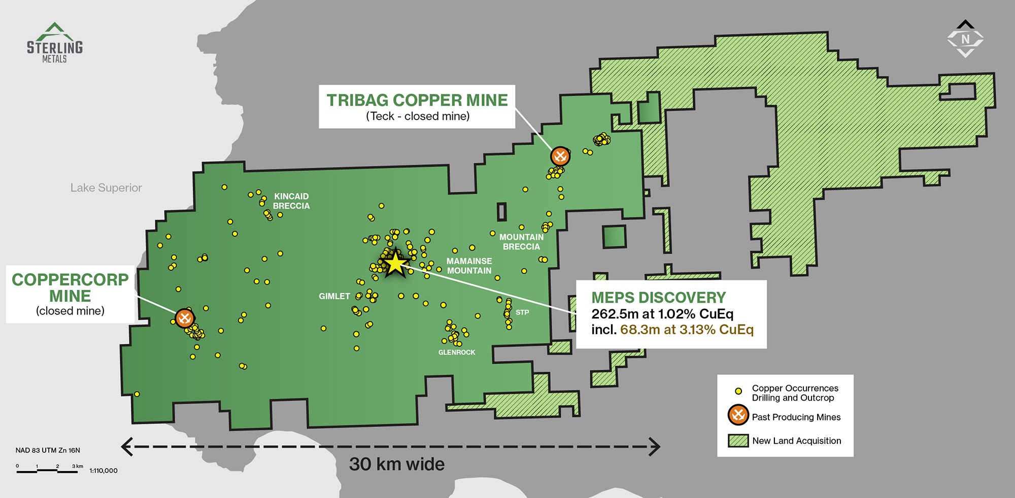
The MEPS Discovery marks the foundation of the Soo Copper Project, with drilling confirming a high-grade porphyry copper system from near surface. Discovery hole MEPS-25-02 returned 262.5 m at 1.05% CuEq, including 68.3 m at 3.25% CuEq
Growing System with Strong Continuity
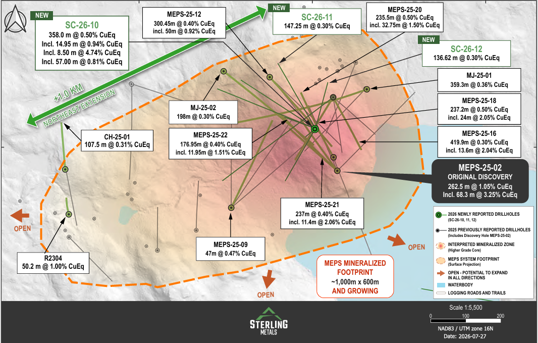
Follow-up drilling has rapidly expanded the footprint and confirmed scale. What began as a compact discovery is now evolving into a kilometre-scale porphyry copper system anchored by a high-grade bornite core.
Ongoing results continue to demonstrate strong lateral and vertical continuity, reinforcing the interpretation of a large, coherent and expanding mineralized system, including:
- A ~400 m × 400 m continuous zone of near-surface copper mineralization centered on the discovery
- Mineralization that remains open in all directions and at depth
- A newly identified blind porphyry stock located ~1.5 km from the discovery, supporting district-scale potential
- Discovery of a bornite–covellite zone to the northwest, with indications of increasing gold grades
Emerging 8 km Copper Corridor
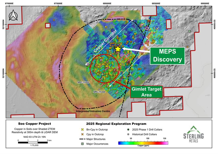
Exploration has expanded beyond the initial discovery area, outlining a broad ~8 km mineralized trend and highlighting the growing scale of the system.
- Copper mineralization is distributed across a wide, multi-kilometre footprint, including the Gimlet target, located ~2 km from the MEPS Discovery and hosting the largest concentration of bornite in outcrop discovered to date
- Reinterpreted ZTEM data (2014) highlights a ~10 km circular geophysical feature, suggesting a much larger mineralized system with significant untested extensions
Data-Driven Discovery
The MEPS Discovery is the result of a systematic, multi-disciplinary approach, integrating modern datasets with reinterpreted historical work.
Sterling’s targeting framework included:
- High-resolution magnetics, including drone surveys
- LiDAR and radiometric surveys
- ~3,000 soil samples defining large-scale geochemical anomalies
- 23 km² of IP/resistivity surveys
- Reprocessing of ~700 km of ZTEM data
- Integration of 60+ years of historical exploration
Historical drilling (~4,250 m) at the Tribag Mine and JR Zone (Jogran Porphyry), originally identified by Phelps Dodge, provided additional geological context that was reinterpreted within this modern framework.
2026 Drill Program
The ongoing ~20,000 metre drill program is focused on expanding the MEPS Discovery and testing additional porphyry centres along the corridor. A combination of step-out and infill drilling is being used to extend mineralization and improve continuity, supporting a transition toward resource-style drilling and future mineral resource definition.
Technical Report
Qualified Person's Statement
Jeremy Niemi, P.Geo., Senior Vice President of Exploration and Evaluation to Sterling Metals, and a Qualified Person within the meaning of National Instrument 43-101 Standards of Disclosure for Minerals Projects, has reviewed and approved the technical information presented herein.