Summary
- 25,000ha high-potential brownfield copper-moly-silver-gold project associated with the Midcontinent Rift (“MCR”) in Ontario, Canada, which until 2021 had never been fully consolidated
- Recent porphyry and breccia drill holes as well as past copper production from two mines suggest the potential for larger intrusion related copper mineralization
- The project benefits from its strategic proximity to substantial infrastructure
Location and Ownership
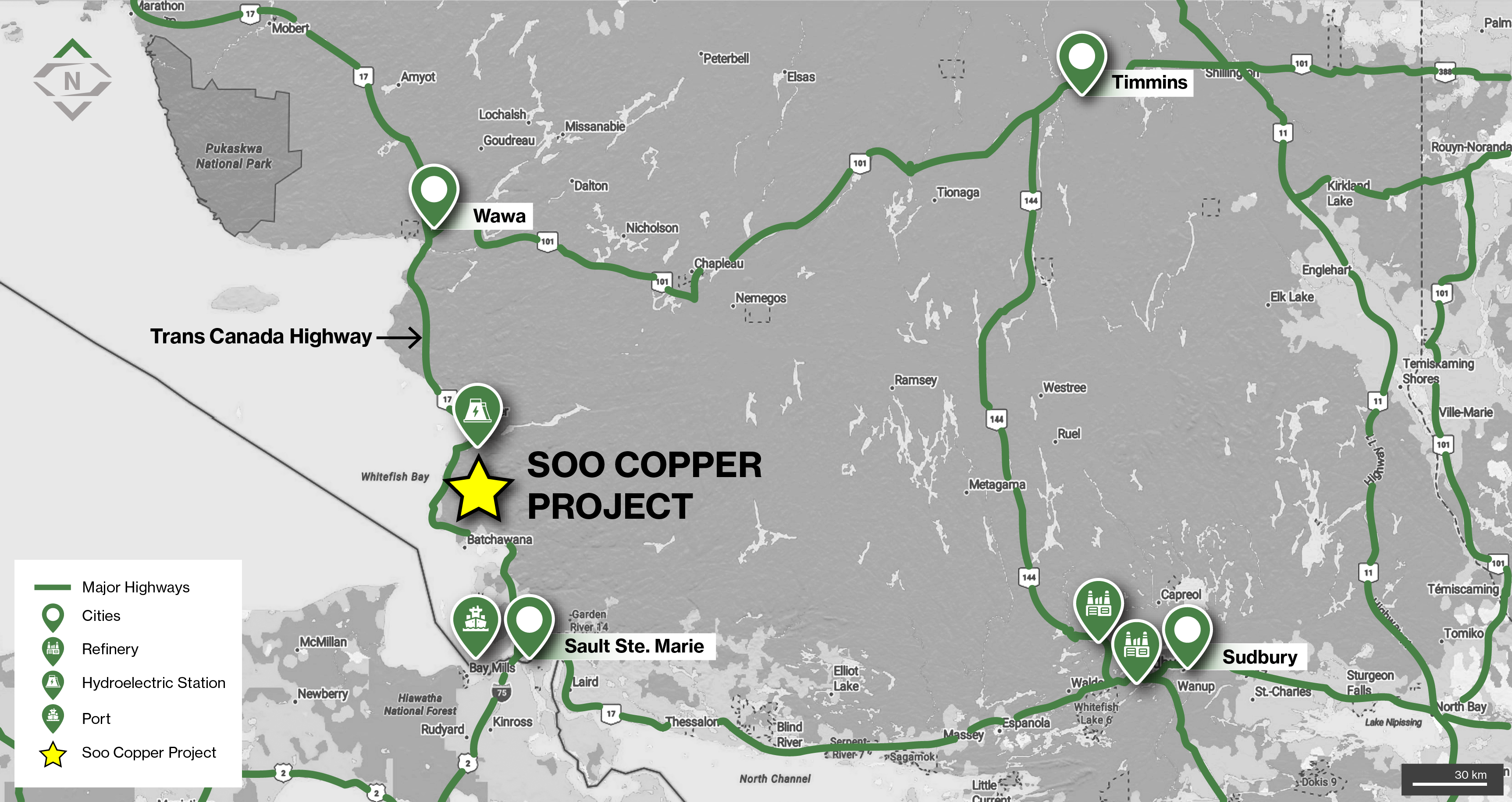
Location of the Soo Copper Project in Ontario, Canada located in proximity to significant infrastructure
- 100% owned and located in an area with a rich mining history, 30km from Batchewana Bay and situated between Wawa, Sault Ste. Marie, Sudbury and Timmins in Ontario, Canada
- The project is intersected by numerous highways and roads including the Trans-Canada Highway (Highway 17), which crosses the westernmost portion and provides major road connection to the city of Sault Ste. Marie
- The project is located 90km from the Port of Sault St Marie, and 40km from the Montreal River, which includes four hydroelectric dams and generating stations
- The project is also ideally located in proximity to two copper smelters outside of Sudbury
Geology
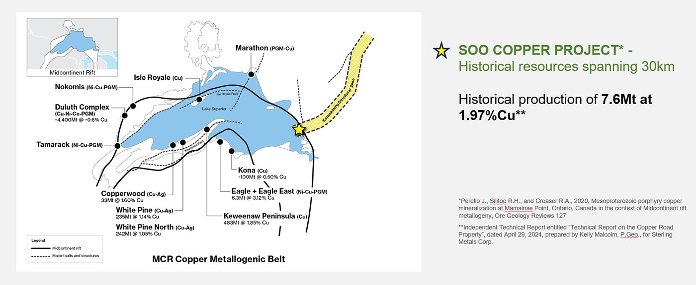
- Situated within the Mamainse Point Formation of the Keweenawan Group within the Proterozoic Southern Province, on the eastern edge of the MCR
- The MCR is home to numerous past-producing and present deposits around Lake Superior, including the prolific native copper deposits of the Keweenawan Peninsula in the U.S., mined for more than 150 years
- Porphyry mineralization at Soo Copper has been sourced to the same age range as the primary mineralizing event within the MCR1
- The Mamainse Point area has a long history of prospecting, exploration, and mining activity dating to the mid-1800’s with the production of copper, silver, and gold from the Copper Corp Mine from 1965 to 1972 and the Tribag Mine from 1965 to 1973, now known as the Soo Copper Project
- The Copper Corp mine reportedly produced 1.1Mt at 1.2% Cu while the Tribag Mine produced 6.5Mt tons at 2.75% Cu1
- Following closure of the mines, significant sections of the district were closed to staking by the Ontario Government
- As a result of this, and fragmented land ownership, the area has seen only sporadic mineral exploration since the 1970
1 Independent Technical Report entitled “Technical Report on the Copper Road Property”, dated April 29, 2024, prepared by Kelly Malcolm, P.Geo., for Sterling Metals Corp.
Exploration
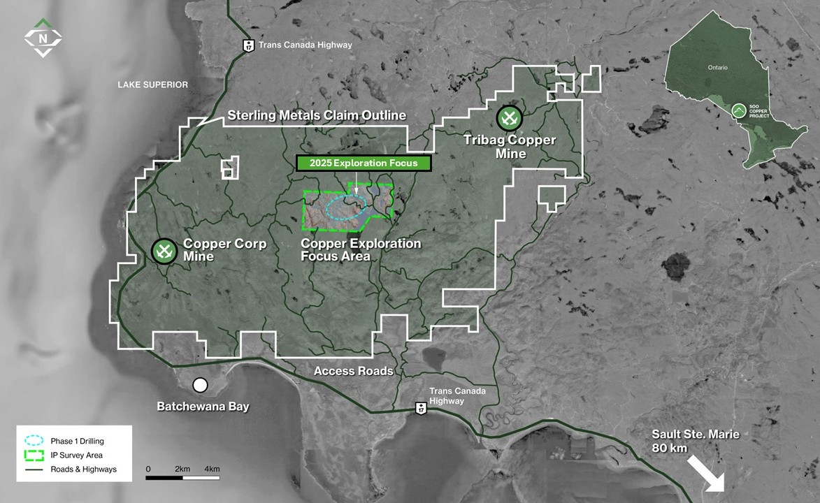
Figure 1: The Soo Copper Project located 80 km north of Sault Ste. Marie, Ontario, spans 25,000 hectares and extends 30 km in width. The Project benefits from proximity to key infrastructure and excellent accessibility, facilitating efficient exploration and development. The 2025 drilling program is concentrated in the central corridor of the Project, while historical mining activity at the Copper Corp and Tribag Breccia Mines is situated along the property's fringes.
- Since 2017, Copper Road Resources Inc., the previous operator, completed ~4,250m of drilling focused on confirming and extending mineralization at the past-producing Tribag Mine and the JR Zone (Jogran Porphyry), originally discovered by Phelps Dodge in the 1960s.
- Sterling Metals officially acquired the project in May 2024; work to date includes ~3,000 soil samples, 23km2 of IP/Resistivity, 700 km of ZTEM reprocessed, review of 60+ years of historical data, and two phases of exploration, as outlined below.
Phase I Exploration
- In May 2025, Sterling successfully concluded its maiden drilling campaign, comprising four diamond drill holes totaling 1,789m. All holes intersected significant copper porphyry mineralization including:
- MJ-25-01 intersected a continuous 359.3-metre zone grading 0.36% copper equivalent (CuEq) from near surface, including 75m at 0.56% CuEq.
- Hole CH-25-01 was drilled 1km away from the first hole and into a resistivity low, returning 107.5m grading 0.31% CuEq, including a higher-grade interval of 30.3m at 0.74% CuEq.
- Follow up holes MJ-25-02 and MJ-25-03 intersected long mineralized intervals, including 198m at 0.30% CuEq and 120m at 0.30% CuEq, respectively.
- The strongest copper mineralization is associated with a newly discovered three-phase porphyry dyke swarm (the GFP Porphyry), indicating a highly permeable, magmatic-hydrothermal structural corridor.
- Geochemical sampling has outlined a 4 km soil anomaly in the +95th percentile, remaining open to the south and east toward the Tribag area, with further sampling ongoing.
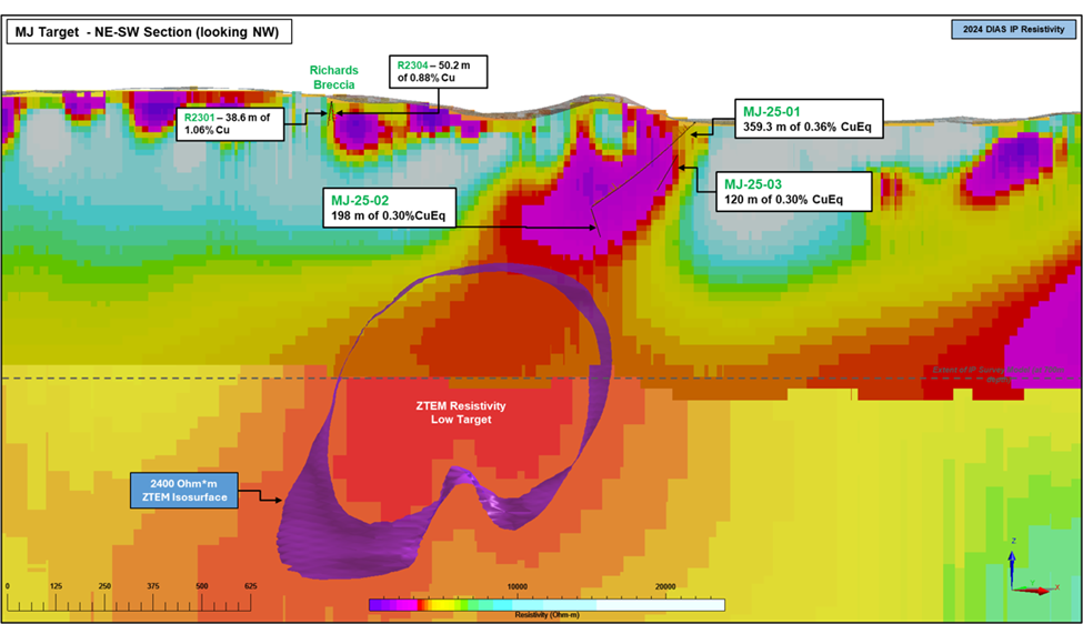
Figure 2. NE-SW cross section showing trace of 2025 holes, mineralization and resistivity from DIAS 3D IP survey in the background which matches porphyry alteration and mineralization.
Phase II Exploration
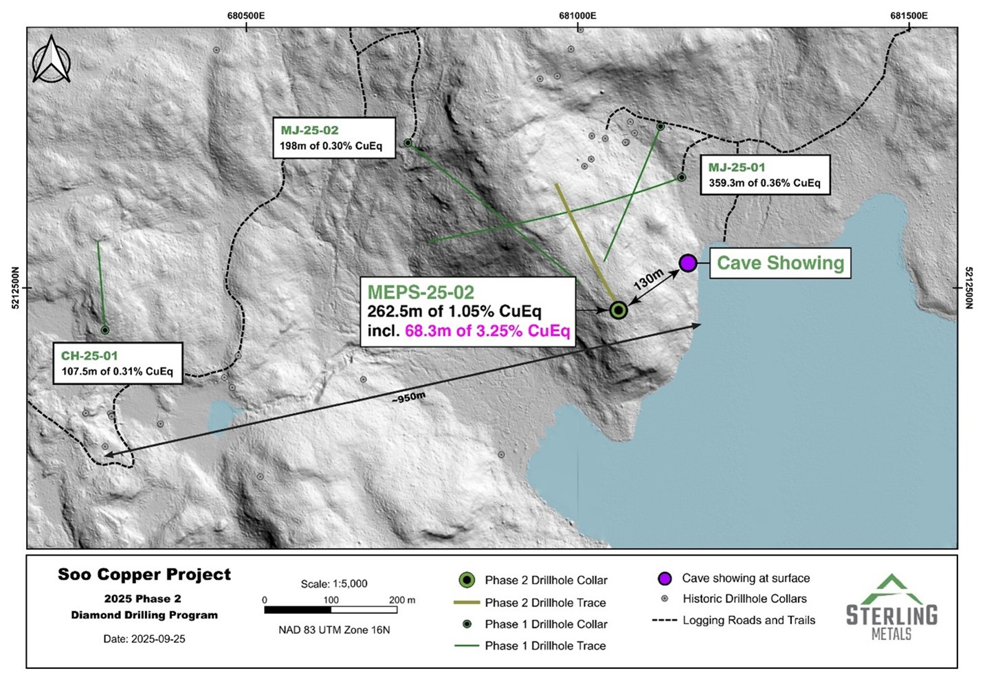
- The Phase II drill program has been increased to a minimum 6,000 m following discovery hole MEPS-25-02, which intersected 262.5 m of 1.05% CuEq from 47.5 m downhole, including 68.3 m of 3.25% CuEq and 9.3 m of 19.98% CuEq.
- This includes the highest copper and gold grades encountered to date at Soo Copper, including: 33% Cu over 0.55m starting at 220.45m depth; and 196 g/t Au and 21.3% Cu over 0.6m starting at 219.85m depth.
- The program is testing four key target areas, including the down-dip extension of the GFP porphyry dyke swarm, the Richards Breccia, and near-surface resistivity lows along a 1.5 km corridor.
MEPS-25-02 and drill hole locations from Sterling Metals inaugural drilling at the Soo Copper Project
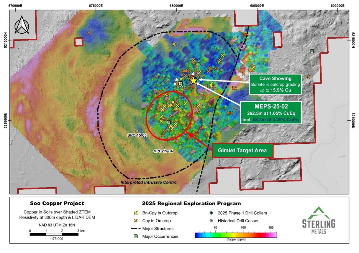
- An expanded regional soil program collected 1,323 new samples, identifying 122 new copper anomalies and extending the mineralized corridor to more than 6 km.
- At the newly defined Gimlet Target Area, the largest concentration of bornite in outcrop to date was discovered through 93 copper-bearing samples, 38 of which contained bornite, collected across 2 km.
- Reprocessing of a 2014 ZTEM survey has revealed a 10km circular anomaly encompassing both the 2025 drilling and the Gimlet Target Area, interpreted as a potential intrusive centre linked to copper mineralization.
Surface sample locations over copper in soils map, over regional ZTEM survey (resistivity) and Lidar.
Technical Report
Qualified Person's Statement
Jeremy Niemi, P.Geo., Senior Vice President of Exploration and Evaluation to Sterling Metals, and a Qualified Person within the meaning of National Instrument 43-101 Standards of Disclosure for Minerals Projects, has reviewed and approved the technical information presented herein.